
As we continue to recover from our lives being upended by the pandemic, we are all learning and relearning to adapt to this new normal and recover from setbacks both small and large. Although climate change is occurring on a longer timescale, dealing with this slow-motion global crisis also requires us to prioritize adaptation and resilience.
In 2018, the Albemarle-Pamlico National Estuary Partnership (APNEP) partnered with the Virginia Institute of Marine Sciences (VIMS) on a project, “Using Natural and Nature-based Features to Build Resilience to Storm-Driven Flooding,” that exemplifies this approach. Tools were developed to show local governments in Virginia and North Carolina ways to decrease their flood insurance costs by utilizing the natural features of the landscape – its marshes, forests, wetlands, beaches, and dunes – to decrease risks from tidal flooding caused by sea level rise.
The goal of the project is to facilitate a win-win situation for both natural and human landscapes, “by increasing the use of natural and nature-based features by local governments as a solution to mitigating storm-driven flooding,” explains APNEP Policy and Engagement Manager Stacey Feken. The NNBF project accomplished this by using interactive maps, fact sheets, and coastal resilience summaries to show local governments how protection of natural marshes, forests, and dunes, and the use of nature-based features such as living shorelines, can result in lower flood insurance costs for home and business owners in the community in addition to flood mitigation benefits.

Image: Coastal VA NNBF Fact Sheets from VIMS website
One flood insurance program focused on by the project was the FEMA National Floodplain Insurance Program’s Community Rating System (CRS). “You receive a score based on the combined practices and programs your community has implemented,” says Mason. The lower CRS class ratings (on a scale from 1-10), the greater the reduction in flood insurance premiums for local governments and therefore the constituents in their locality. Although many local government officials are aware of these programs, time and resource constraints often prohibit them from taking full advantage of them. However, "The Community Rating System is very popular with property owners” notes Ross Weaver, the Program Assistant Director for Wetlands Watch, a non-profit based in Norfolk, VA who was a collaborator on the project. Ross says this is because the CRS “provides property owners with a direct benefit in the form of a discount on flood insurance premiums. One of the highest scoring activities is preservation of open space within the floodplain, so any tool that makes it easier for local government staff to identify those opportunity areas and increase their CRS points can be extremely valuable.”
The VIMS NNBF mapping tool aims to change that by helping local governments to easily identify and prioritize the conservation of NNBFs that provide the most flood mitigation services for their communities, as well as to see which areas would benefit from the construction of new NNBFs such as living shorelines or riparian buffers. “You have this two-pronged approach,” says Mason, “one is to prioritize existing NNBFs for protection, and then the other is to identify places where projects can go on the ground to improve coastal resilience.”
The project also incorporates other ecosystem services provided by NNBFs, such as water quality protection, that allow communities to receive credit for features that provide stormwater control through reduction in nutrients and sediment loading. These credits can assist local governments with meeting regulatory requirements including the Chesapeake Bay Resource Protection Area buffers to protect water quality in adjacent water bodies. Natural and nature-based features, along with other services such as habitat for wildlife and recreation opportunities, allow localities to receive multiple benefits from protecting and restoring natural areas.

Image: Living shoreline installation led by N.C. Coastal Federation at Carteret County Community College for increase habitat and preventing erosion.
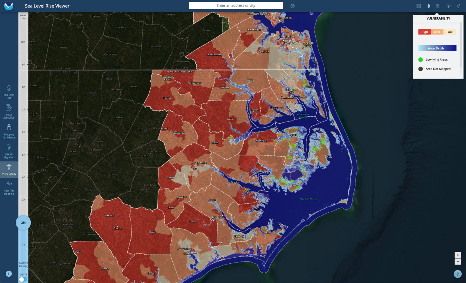
Although the VIMS project team and partners, which include Wetlands Watch, the Virginia Coastal Policy Center (VCPC) at William and Mary Law School, and APNEP, were originally planning on sharing the tool via in-person outreach, COVID-19 meant that this effort went virtual for quite some time. In addition to a main information hub on the VIMS Center for Coastal Resources Management website, the team uploaded map layers and data to an integrated viewer on the ADAPTVA website, a one-stop shop for information about climate adaptation projects and products. “Folks in local governments will be able to open up this viewer and they’ll be able to see where sea level rise is projected to be, they’ll be able to see where the NNBFs are and rankings are, and they’ll be able to see the target areas for projects,” says Mason. In addition, Wetlands Watch and the VCPC have developed publicly available fact sheets about the different NNBFs.
Weaver points out that the greatest benefit of AdaptVA is that it combines multiple different resource to be viewer an individual map. Weaver adds “This layered approach allows users to visualize data in a way that facilitates planning for multiple benefits based on environmental factors like water quality and habitat protection, but also considerations for the built environment, such as proximity to critical infrastructure, potential for flood mitigation, and social vulnerability.”

Image: Adapt VA Interactive Map (ADAPTVA)
Feken sees APNEP collaborating with the project team to support implementation efforts that are already underway as a result of statewide resilience planning in both NC and VA. “This has been a wonderful opportunity to expand our partnerships in Virginia and not only learn from each other but also work together across state lines."
APNEP Director Bill Crowell adds, “It’s allowed us to build upon our 2017 and 2020 Memorandum of Understanding (MOU) with Virginia, and long history of collaborating across state lines to work together in our shared waterways that flow into Albemarle Sound.” APNEP looks forward to strengthening existing relationships and creating new ones that will build momentum for expanding interstate collaboration on regional issues that cross jurisdictional boundaries into the future.
Learn more from the Coastal Resilience Community of Practice meeting notes.